--You cannot teach geography in any way so effectually as by setting the pupil to construct the map from the dissected parts.
--Exceedingly valuable in imparting novelty and interest to a useful study.
--An agreeable contrivance for blending amusement with instruction.
--In putting these maps together, which children delight to do, they will learn "geography without a master," and keep quiet as a mice.
--Every family should possess this series of maps that the younger members may profitably while away their leisure hours. Nothing can be more useful.
--An ingenious device for teaching geography.
--Physic and geography were equally distasteful in our youthful days, but sugar coated pills have induced children to cry for the first, and we venture to assert that the ingenious originators of this idea, have rendered the second attractive.
[press quotes printed inside the box lid of the Merriam game seen below]

These maps of the Caribbean Antilles and China are details from a map game conceived by the Benedictine priest, Don Casimir Freschot and published by Giovanni Pare in Venice in about 1680.
"This game is probably the earliest geographical game ever published." [!??]Freschot was an author of about 50 books, mainly on history subjects, and a few dedicated to Venice and its nobility. While in Venice he also composed a goose game to facilitate "the teaching of geography to the young venetian nobility". The copper plate was engraved by Lucini and comprised 4 larger maps of the continents and 153 smaller maps of other areas and with a prospect of Venice at the center of it. There is only one known example in existance of the full broadsheet at the Biblioteca Nazionale Marciana in Venice. [source]

A Journey Through Europe or the Play of Geography [1759]
This game is believed to be the first or one of the first known games in the English-speaking world to be attributed to an individual designer. It was first published by Carrington Bowles, a British publisher of hand-tinted, cloth-backed maps. This game reconfigured a map of Europe to provide a game rather than a reference. It's a straightforward track game.
The game uses a teetotum - a spinning top with numbered sides - as dice were viewed as gambling instruments that would not be permitted in respectable households. The players begin and end in London, and many spaces advance players or transport them to other portions of the board. For example, a playing piece that lands on Hanover "shall by order of Ye King of Great Britain who is Elector, be conducted to ... Gibraltar to visit his countrymen who keep garrison there" while the playing piece that lands on "Rome for kissing ye Pope's Toe shall be banished for his folly to ...the cold island of Iceland and miss three turns".
[source/info: link / link / link / link /]

This map is a jigsaw puzzle. It was designed by John Spilsbury in 1766. Spilsbury, formerly the apprentice to the Royal Geographer, is believed to have been the first commercial manufacturer of jigsaws. He managed to start quite a trend. For a good 20 years during the mid 1700s, all manufactured jigsaws were in the form of dissected maps like Spilsbury's.
The maps were designed as teaching aids for geography classes. As pupils put the pieces together, they would learn how different countries connected to one another.
John Spilsbury certainly spotted a business opportunity. In the space of two years he marketed the eight map subjects most likely to appeal to upper class English parents: the world, the four continents then known (Africa, America, Asia and Europe), England and Wales, Ireland and Scotland.
This map is a rare survivor - only one other Spilsbury map is known to exist in a British public collection. [source]
Incidentally, the cartographer John Spilsbury is widely credited as being the inventor of the jigsaw puzzle during the 1760s. [All the earliest jigsaw puzzles were in fact maps (or more correctly, 'dissected maps' - they weren't dubbed 'jigsaw puzzles' until the early 1900s)]. Spilsbury was almost certainly the first commercial producer of the dissected maps but controversy remains as to whether or not he actually 'invented' them originally. [see: Who Invented the Jigsaw Puzzle? at icollectpuzzles]


Published by John Wallis in London in 1794. Dissected and laid on linen. [source]
First Edition of this famous map-game, which was reprinted in 1802 & 1811 (and probably at other times). A rare specimen of the craze for educational games that swept Europe and Great Britain in the late 18th and early 19th centuries, this highly attractive map is the game board for an edifying tour of the leading cities of the Continent and the British Isles.
[source/info: link / link / link / link /]
Spilsburys Jigsaw Puzzle Map
This map is a jigsaw puzzle. It was designed by John Spilsbury in 1766. Spilsbury, formerly the apprentice to the Royal Geographer, is believed to have been the first commercial manufacturer of jigsaws. He managed to start quite a trend. For a good 20 years during the mid 1700s, all manufactured jigsaws were in the form of dissected maps like Spilsbury's.
The maps were designed as teaching aids for geography classes. As pupils put the pieces together, they would learn how different countries connected to one another.
John Spilsbury certainly spotted a business opportunity. In the space of two years he marketed the eight map subjects most likely to appeal to upper class English parents: the world, the four continents then known (Africa, America, Asia and Europe), England and Wales, Ireland and Scotland.
This map is a rare survivor - only one other Spilsbury map is known to exist in a British public collection. [source]
Incidentally, the cartographer John Spilsbury is widely credited as being the inventor of the jigsaw puzzle during the 1760s. [All the earliest jigsaw puzzles were in fact maps (or more correctly, 'dissected maps' - they weren't dubbed 'jigsaw puzzles' until the early 1900s)]. Spilsbury was almost certainly the first commercial producer of the dissected maps but controversy remains as to whether or not he actually 'invented' them originally. [see: Who Invented the Jigsaw Puzzle? at icollectpuzzles]
Wallis's Tour of Europe A New Geographical Pastime
Published by John Wallis in London in 1794. Dissected and laid on linen. [source]
First Edition of this famous map-game, which was reprinted in 1802 & 1811 (and probably at other times). A rare specimen of the craze for educational games that swept Europe and Great Britain in the late 18th and early 19th centuries, this highly attractive map is the game board for an edifying tour of the leading cities of the Continent and the British Isles.
The players use a 'totum' and "pyramids or travellers" to compete: each player in turn rolls the totum and moves his piece along a route of numbered cities and locations, the final goal being arrival in London, "the first city in Europe." In addition to the luck of the roll, players must cope with delays in some cities--in Florence a Traveller must "stay here one turn to see the fine paintings in this place", and disasters elsewhere, if a player lands on the Scilly Islands, "by running foul of the rocks, the Traveller loses the game." All editions of this work are uncommon. [pba]

Hand-coloured engraved paper on linen published in London by William Darton in 1810. In order to play this European centred race game each player must have a marker, usually in the shape of a pyramid, and four counters. An eight-sided teetotum spinner is also needed. There are 133 playing spaces covering the map playing surface, beginning in London and ending in Athens. A separate booklet sets out the rules and the rewards and forfeits for each numbered space. As well as providing information on the history and commerce of the places, the game also encouraged reading and conversational skills. [source]
UPDATE (Jan, 2010): Walker's Tour Through England and Wales, a New Pastime, London, 1809 at MDZ.
Walker's New Geographical Game Exhibiting a Tour Through Europe
Hand-coloured engraved paper on linen published in London by William Darton in 1810. In order to play this European centred race game each player must have a marker, usually in the shape of a pyramid, and four counters. An eight-sided teetotum spinner is also needed. There are 133 playing spaces covering the map playing surface, beginning in London and ending in Athens. A separate booklet sets out the rules and the rewards and forfeits for each numbered space. As well as providing information on the history and commerce of the places, the game also encouraged reading and conversational skills. [source]
UPDATE (Jan, 2010): Walker's Tour Through England and Wales, a New Pastime, London, 1809 at MDZ.

The Travellers or A Tour Through Europe 1842
Designed by William Spooner, the players in this game race from separate starting cities to designated destination cities. Certain spaces on the board require the player to pay or collect tokens from a pool. The first player to reach his destination takes all of the tokens from the pool. [source]

Wallis’s Picturesque Round Game of the Produce &
Manufactures of the Counties of England & Wales (c. 1826-37)
Educational map game of England and Wales, designed to teach notable aspects of each county. Produce and manufacturers are illustrated in pictorial style and numbered on variously colored counties, together with famous sites and popular pastimes.
The map also includes topographical features such as mountains, bodies of water and forests. Ships dot the seas. The cartouche, in the form of a castle wall in ruins, is surrounded by scenes of a farmer and wife, railroad, ships, etc. The game takes the form of a “dissected” (sectioned folding) map, that opens into a race game that starts at the mouth of the Thames and travels along 151 stops to the destination of London. For example number 10, Ely, was known for eels and strawberries, and number 126, Dorchester, was known for butter and strong beer. Originally published by Edward Wallis between 1826 and 1837, Wallis’s publication line appears on the map. The name of John Passmore, who took over Wallis’s stock in 1847, appears on the instruction booklet.
The Bodleian Library at Oxford University in England has both the Wallis and Passmore editions of this game in their collection, and both the British Library and the University of Wales have the 1844 edition. The game was innovative with respect to its cartographic style combining correct county boundaries and non-traditional pictorial design.
The map is dissected, backed on linen, and folds into cloth covers, as issued. A 12-page booklet published by Passmore includes rules, explanations, and data. Apparently the game was originally issued with a “Card” containing 9 letters, 9 numbers, 2 crosses and one blank, not present in this set. Players were to supply their own “counters” or “tetotums.” The original booklet suggests that the game be played for a prize such as “fruit, raisins, nuts, cakes, &c,” or if played for money, it was suggested that “the winners will have the privilege of contributing the money that have gained to any benevolent or charitable object which shall be recommended by the lady of the house.” [source / Bodleian / Glazer]
Despite this print appearing in quite a few repositories, I haven't been able to find a large version. However, I spliced together a partially complete high(ish) resolution image from the Aberystwyth site that can be seen here.
The Bodleian Library at Oxford University in England has both the Wallis and Passmore editions of this game in their collection, and both the British Library and the University of Wales have the 1844 edition. The game was innovative with respect to its cartographic style combining correct county boundaries and non-traditional pictorial design.
The map is dissected, backed on linen, and folds into cloth covers, as issued. A 12-page booklet published by Passmore includes rules, explanations, and data. Apparently the game was originally issued with a “Card” containing 9 letters, 9 numbers, 2 crosses and one blank, not present in this set. Players were to supply their own “counters” or “tetotums.” The original booklet suggests that the game be played for a prize such as “fruit, raisins, nuts, cakes, &c,” or if played for money, it was suggested that “the winners will have the privilege of contributing the money that have gained to any benevolent or charitable object which shall be recommended by the lady of the house.” [source / Bodleian / Glazer]
Despite this print appearing in quite a few repositories, I haven't been able to find a large version. However, I spliced together a partially complete high(ish) resolution image from the Aberystwyth site that can be seen here.

Wallis's New Game of Wanderers in the Wilderness
Hand-coloured etching on linen, published 1818-1847. The Wilderness in this case is South America, a

A plain map or emblematic chart for the geographical game of Europe,
according to the method of the Abbe Gaultier. By Mr. Wauthier, his pupil, 1797.
Hand-coloured engraved outline map showing unnamed countries, rivers, mountains, cities, etc. [this edition published in 1821]
Publication Title: 'A complete course of geography, by means of instructive games, invented by the Abbe Gaultier. Collated with the author's last Paris edition, and digested for Europe conformably to the territorial arrangements of the Pacification of 1815, by Jehoshaphat Aspin. In three parts. The first part, containing the game of simple geography, for teaching the names and situations of the different countries and places of the Earth. The second part, containing a concise treatise on the artificial sphere. The third part, containing a geographical game, illustrative of ancient and modern history ... London: printed for John Harris and Son, corner of St. Paul'sChurch-yard.'

La récréation Européenne ou jeu des princes de l'Europe
Hand-coloured etching made by Maurille Antoine Moithey; published in Paris in 1770 by Jean Baptiste Crépy.
Game board with 61 circular numbered compartments arranged in a spiral, each containing a map of a state, with the state named beneath, the first being Spain and the last being France; in the centre the large final compartment containing a map of France, a map of Europe, beneath which, the royal coat of arms.
Inscription Content: Lettered with the title on either side of the coat-of-arms, reading "LA RÉCRÉATION EUROPÉENE/ou jeu des princes de l'Europe/ Dedié et Présenté/ à Nosseigneurs les Enfans de France", beneath which, on the l,"Se vend à Paris chez Crepy rue S. Jacques prés/ la rue de la parcheminerie à S. Pierre" and to r "Par leur treshumble et tres obeissant/ serviteur Moithey Ing. / Geographe"; in the bottom margin "On trouvera chez le Sr Crepyune Collection de Jeux adaptés à la Géographie, l'Histoire, et à l'Art Militaire, et autres propres à recréer etinstruire la Jeunesse" and to r, "Avec Privilege du Roi". [source]

L'Historiographie du Royaume de France
Hand-coloured anonymous etching published in Paris between 1740-1768.
Game board with numbered compartments from 1 to 108 arranged in a spiral, the more elaborate compartments bearing a cartouche with the name of a region in France, beneath which are listed its principal industries, the subsequent compartments containing lists of its principal cities and towns, with a key to their status, the final compartment being Paris, surmounted by a portrait medaillion of Louis XV.
In the centre, a map of France, showing all the towns mentioned in the game, above which is the title and a description of the map; to the left of the map, the rules, to the right, a description of the "Air, Sol, Peuples, et Villes" of France, the longitudes and latitudes of the principal towns, and a key. [source]

Jeu Géographique de la République Français
Published at Chez Basset in Paris in 1795. J.N. Mauborgne, a former professor of geography in Paris, created this “geographical game of the French Republic”in honor of the government of the National Convention during the French Revolution. Mauborgne’s game involvestraveling around republican France, which was divided into 83 'departments', the new unit of territorial administration that the Revolution introduced to replace the much larger historical provinces.
Each space on the map shows a different department with its departmental capital, or chef-lieu. Players move counter-clockwise about the board from department to department, ending on the Mediterranean island of Corsica, which is draped in thewords “liberty” and “equality” and crowned by a Phrygian bonnet dangling on a pike. The game board also features, in the upper left hand corner, an inset map of France’s Caribbean colony of Saint-Domingue and numerous Gallic roosters, which the Revolution transformed into a popular national image. [source]

Le Jeu de France
Published by Etienne Vouillemont in Paris in 1659. Pierre Duval was a nephew of the great French geographer Nicolas Sanson who rose to become 'geographer to the king' in his own right. In the 1660s and 1670s he published a large number of atlases and geographic works. Duval was the first in France to conceive of geographical games that aimed to inform and instruct while providing entertainment.
Jeu de France (The game of France) is a chutes-and-ladders game made up of 63 squares, each representing a province, except for the last, which contains a map of the entire kingdom. The game offers insight into the clichés and stereotypes that Parisians applied to the French provinces. Brittany is noted for its debauchery, Tours for its lovely avenues, Forez for its knives and scissors, and Ponthieu as a theater ofoperations for the king’s army (a reference to the recent Franco-Spanish war). [source]

France - Provinces et Départements
Published in 1870. Map in full color. Game cards attached to right side with elastic bands. Legend and instructions included on game board. Complete with 36 cards of the Provinces. A very elegantly made game. Game board in full color with uncolored vignettes of France scenes (complete with numbered areas) in each corner. Map case folds and locks with metal clasps to give the appearance of a book. [source]

Waterloo [1895]
Very little is known about this game. The map shows a area from Versailles and Paris on one side and Brussels and Namur on the other. Key towns/cities (in gold) include Quatre Bras and Ligny. It seems to be a forerunner for Kreigspiel Junior with its point to point movement system. The gameboard is the top of the box (wooden) which also has a slot for the game pieces. [source]
[googlemaps / Waterloo campaign map]

The Traveller's tour through the United States
Hand-coloured print published by F & R Lockwood in 1822
The board is a map of the United States c. 1822, the westernmost states being Missouri and Louisiana. Because dice were frowned upon as instruments of the horrible vice of gambling, included a teetotum, a sort of spinner used to randomly yield a number from 1 to 8. This is used to determine the first player. Lines are drawn on the map to connect cities in a continuous path which players must follow. However, the cities are not named, but numbered.
Upon arrival, at a new city, the player must correctly name the place and, if playing the advanced version, its population, or lose a turn and try again. The first to reach New Orleans (population 10,000) wins. The first known game published in the United States [?!]. Unlike other games, it was also invented in the USA rather than being a copy of a British game, as many later ones were. The publisher were sellers of books in New York and later in 1822 also released Traveller's Tour Through Europe. [source: NYPL / BgG]


'Norris' Cyclopaedic Map Of The United States Of America, (Excepting Alaska) Together with adjacent portions of the Dominion of Canada and of the United States of Mexico ... Prepared for use in schools and in the home circle. Patented June 12, 1883. Originated, Manufactured and Published by W.R. Norris, New York. 1885.'
An unusual geographical game played with a map of the United States (painted on wooden slats that roll up) and pins with the names of cities. Under the title is the explanation: 'The cyclopaedic character is derived from the combination of the map proper with its descriptive blocks representing capitals and business centers, and which always accompany it.' There is also a printed sheet of instructions - 'Rules for playing the games of the Zylo-Karta.' [source]


Dissected Outline Map of the United States of America
Published by Milton Bradley in Springfield, Massachusetts in 1880.
69 piece cardboard puzzle. Map of U.S. Verso, industrial scenes. On the inside of the box cover is a map of the U.S. and some explanatory text: "The map is engraved in outline ... On the back are illustrations of the prominent industries ... the whole forming a complete object lesson of the geography and natural history of the United States. This is by far the largest and finest dissected map published..." [source]
For non-Americans: note the single Dakota (the 2 states were admitted into the Union in 1889) and 'Indian Territories' for Oklahoma (1907) (I think it's seen in most/all the USA maps here).

Rambles Through Our Country - An Instructive Geographical Game for the Young
Published by the American Publishing Company Hartford in 1886 with chromolithography by Schaefer & Weisenbach {or they were later publishers}. [source / LoC]


Clemens' Silent Teacher. Dissected Map of the United States and of Each State in Counties. Manufactured in 1893 by Rev. E.J. Clemens, Clayville, N.Y.
Box cover shows an American handing out puzzles to people from different countries dressed in national costumes. State map boxes sit in the bottom left-hand corner. The jigsaw puzzle uses a Colton Map of the United States. The map is two sided. On top side is a map of the United States. The bottom side is an advertisement for Sherwin Williams. [source]
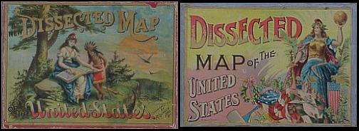
Edition box covers for dissected map games. The University of Florida at Tampa has a 9 minute film on youtube about the background and symbolism of that print on the left. [source]

Map of the United States and Candada from Merriam,
Moore's + Co's Series of Dissected Maps [published in 1853]
Merriam, Moore & Co. produced a series of dissected maps of the United States including the Eastern, Middle, Southern, Western, and New York State. The puzzle sits in a wooden case 24x17 designed to look like a book with a metal clasp to keep it shut. The inside cover includes reviews of the puzzles and a list of other available dissected maps. [source]


Atlas Geographique: Amerique du Nord; Amerique du Sud; Oceanie;
Afrique; Asie; Europe et ses Chemins de fer; France et ses Chemins de fer.
Colorful cover showing animals, transportation, and people from each continent. Includes seven puzzle maps of the continents and France, each laid on a cardboard tray and stacked in a box with an elaborate, color view of people and scenes from around the world. AR Fremin made five of the maps and J Gaultier made two (published by Logerot, Paris in 1850). The date is estimated from the U.S. and Mexican boundary - the maps were probably originally engraved in the 1840's. [source]

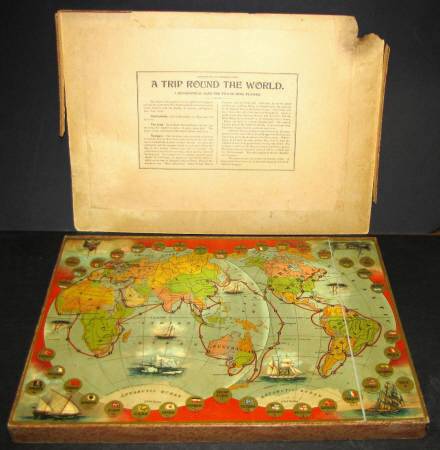
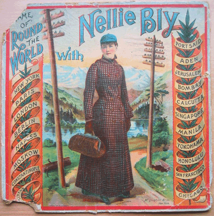
Nellie Bly was the pseudonym for an extraordinary and innovative reporter named Elizabeth Jane Cochrane who worked for the New York World newspaper. After Jules Verne's 'Around the World in Eighty Days' became popular, Cochrane attempted her own world tour (completed in 72 days) and wrote a series of dispatches during the journey around which her employer built a hugely successful article series. Game maps were included with the stories so that the public could follow along at home. The episode gave rise to many world tour map games featuring Bly on the box cover (published up until the 1920s) and inspired entrepreneurs to bring out more variations on the geography game theme for an enthralled American audience.
[see this illustrated 8Mb pdf, 'Around the World and across the Board: Nellie Bly and the Geography of Games' by Edlie L Long - seems to be (a) book chapter(s)?]
The majority of commentary above is either quoted or paraphrased from the source sites.
The array of images presented is neither exhaustive nor meant to be a serious review/sampling. Basically I'm giving up now without really discovering any of the Dutch, German and (no doubt) other versions of these fascinating items of historical ephemera. There is definitely a lot more material online but, as a few of the pictures above demonstrate, the image quality is not always optimal.
Thanks very much to Jamie from the excellent Cartophilia site for providing some link assistance!
There is a LOT to see and read in the following links if you dig around:
- Boardgamegeek [games between 1600 + 1900]
- OldPuzzles.
- Icollectpuzzles.
- Puzzlehistory.
- European Society of Game-Collectors.
- Luding.
- Hordern / Games et al.
- Previously: Board Games and in general, cartography.
- UPDATE: Good sized game maps can be found at Giochi dell'Oca [choose 'geographia' in the category box and hit search]


